Visualising the Conflict
Geographic Information Systems (GIS) Maps
Map Set 8:
Female Death Rates |
| Map Set 8: Female Death Rates - Introduction |
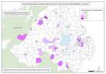
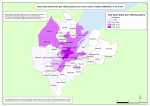
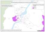
Female Death Rates (per 1000 population) due to the conflict (1969-2001), by area (Northern Ireland, Belfast, Derry), at ward level
3 maps
 This set of maps complements the total death rate maps by providing information on the total female death rate per 1000 population. The information used to locate and plot each death is provided by Malcolm Sutton’s “Index of Deaths 1969-2001” (http://www.cain.ulster.ac.uk/sutton/) . This set of maps complements the total death rate maps by providing information on the total female death rate per 1000 population. The information used to locate and plot each death is provided by Malcolm Sutton’s “Index of Deaths 1969-2001” (http://www.cain.ulster.ac.uk/sutton/) .
The data is mapped at electoral ward level. There are 582 electoral wards in Northern Ireland as defined by the Boundary Commission for Northern Ireland in 1995. The electoral ward shapefile was downloaded from EDINA borders website. (http://borders.edina.ac.uk/html/lut_download/ni_ward.html)
The death rate legend is split into 5 levels for each of the categories/victims mapped. The first level is Nil deaths; the second level is the number of wards which fall in the lowest 50% of death rates; the third level is the number of wards in the next highest 22.5% of death rates; the fourth level is the number of wards in the next 22.5% of death rates; and the fifth level are the wards within the top 5% of death rates.
| Maps - Female Death Rates (per 1000 population) due to the conflict (1969-2001), by area (Northern Ireland, Belfast, Derry), at ward level (3 maps compiled and drawn by Luke Kelleher) |
| Title of Map |
File Version |
| PDF
| L-JPG
| H-JPG
|
 Female Death Rates - NI - Ward Female Death Rates - NI - Ward
Total Female Death Rates (per 1000 population) due to the conflict in Northern Ireland (1969-2001), at ward level. |
pdf
590kb |
.jpg
167kb |
.jpg
1004kb |
 Female Death Rates - Belfast - Ward Female Death Rates - Belfast - Ward
Total Female Death Rates (per 1000 population) due to the conflict in Belfast (1969-2001), at ward level. |
.pdf
465kb |
.jpg
131kb |
.jpg
870kb |
 Female Death Rates - Derry - Ward Female Death Rates - Derry - Ward
Total Female Death Rates (per 1000 population) due to the conflict in Derry (1969-2001), at ward level. |
.pdf
409kb |
.jpg
111kb |
.jpg
694kb |
|

