Visualising the Conflict
Google Maps of Physical Memorials
map development by Julio Lopez Losada (2011) |
Below are links to a set of Google Maps, including Google Street View, which dispaly the information on physical memorials contained in the CAIN database. In addition to the main, or default, Google map there are five alternative versions of Google Maps available to users, so they can select a map which suits their needs.
Each version of the Google Maps also has a number of selectable options for viewing particular information on a map. In addition, each of the five maps has been made available with Google maps API (Application Programming Interface) version 2 and API version 3 (see footnote). Users are free to click on the links below to view each version of the Google map and bookmark any preferred layout.
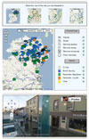
| Map 0: The Main / Default Map |
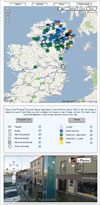 The main map contains:
- Top – Google Map: default zoom set to Ireland with tabs for quick zoom to Ireland, Belfast, Derry and Middle Ulster;
- Middle – Selection options 'visible' (for type and status of memorial); and
- Bottom – Google Street View.
Main / Default Google Map:
http://cain.ulster.ac.uk/victims/gis/googlemaps/index.html
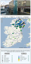 Map 1 contains: Map 1 contains:
- Top – Google Street View;
- Middle – Google Map: default zoom set to Ireland with tabs for quick zoom to Ireland, Belfast, Derry and Middle Ulster; and
- Bottom – Selection options 'visible' (for type and status of memorial).
API Version 3:
http://cain.ulster.ac.uk/victims/gis/googlemaps/map1V3.html
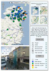
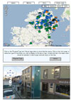 Map 2 contains: Map 2 contains:
- Top – A shortened/smaller
Google Map: default zoom set to Ireland with tabs for quick zoom to Ireland, Belfast, Derry and Middle Ulster;
- Middle – Selection options 'hidden' (for type and status of memorial); and
- Bottom – Google Street View.
API Version 3:
http://cain.ulster.ac.uk/victims/gis/googlemaps/map2V3.html
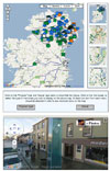 Map 3 contains: Map 3 contains:
- Top left – Google Map: default zoom set to Ireland;
- Top right– A panel (vertical format) with quick zoom options from four thumbnail maps: Ireland, Belfast, Derry and Middle Ulster;
- Middle – Selection options 'hidden' (for type and status of memorial); and
- Bottom – Google Street View.
API Version 3:
http://cain.ulster.ac.uk/victims/gis/googlemaps/map3V3.html
 Map 4 contains: Map 4 contains:
- Top – A panel (horizontal format) with quick zoom options from four thumbnail maps: Ireland, Belfast, Derry and Middle Ulster;
- Middle left – A smaller Google Map (set to Ireland);
- Middle right – Selection options 'visible' (for type and status of memorial); and
- Bottom – Google Street View.
API Version 3:
http://cain.ulster.ac.uk/victims/gis/googlemaps/map4V3.html
 Map 5 contains: Map 5 contains:
- Top left – A smaller Google Map (set to Ireland));
- Top right – A panel with quick zoom options from four thumbnail maps: Ireland, Belfast, Derry and Middle Ulster;
- Bottom left – Google Street View; and
- Bottom right– Selection options 'visible' (for type and status of memorial).
API Version 3:
http://cain.ulster.ac.uk/victims/gis/googlemaps/map5V3.html
The Google maps Application Programming Interface (API) was available as Version 2 when work first began on the 'Visualising the Conflict' project. However, a new API Version 3 became available during the life of the project. Upon inspection there were some slight differences in the way the two APIs worked with the underlying data and displayed the maps. Given that API Version 2 may not be supported by Google into the long term it was felt prudent provide versions of the Google maps using both APIs.
|